
GPS Jamming at Sea: What’s Happening, Why It Matters – and How to Track It
In recent years, GPS jamming and spoofing have escalated from isolated disruptions to a persistent threat in maritime regions worldwide. Areas such as the Gulf of Finland, the Red Sea, and the Mediterranean have seen a dramatic rise in interference events, disrupting navigation, posing security risks, and putting both vessels and critical infrastructure at risk.
The Alarming Rise of Interference
In the Baltics, especially near Finland, maritime pilots have reported GPS outages during up to 90% of their voyages in 2024. In May 2025, the grounding of the MSC Antonia near Jeddah was likely the result of a spoofing incident. These are not isolated events, they signal a broader trend where jamming and spoofing are used to conceal illegal activities, undermine national security, or target vital infrastructure.
The equipment required to launch such attacks is disturbingly accessible. Basic jamming devices can be purchased for under $100, while state-sponsored campaigns can affect entire maritime regions. In fact, tracking anomalies caused by spoofing have jumped from 600 km to over 6,000 km according to industry rapports in early 2025 alone, a tenfold increase in just a few months
Many incidents have been linked to hybrid campaigns believed to originate from hostile state actors, aiming to destabilize NATO-aligned regions. In response, some airports in countries like Estonia and Poland have even suspended flights due to signal unreliability.
Why GPS Jamming Should Worry Maritime Operators
At sea, GPS is more than just a positioning tool, it is a lifeline. When it’s disrupted:
- Criminals gain cover to carry out illegal operations under the radar.
- Navigational errors increase the risk of collisions, groundings, or port disruptions.
- Critical infrastructure like subsea cables and pipelines and offshore platforms, becomes more vulnerable to sabotage or misidentification.
- National and regional security suffers, especially in geopolitically tense zones.
The U.S. Department of Homeland Security has labelled GPS as a “single point of failure” for critical infrastructure, underlining the stakes.
Our Answer is GPS Lost
At Gatehouse Maritime, we’ve developed an analytical feature to help address this threat. It’s called GPS Lost and it brings visibility to a challenge that thrives on opacity.
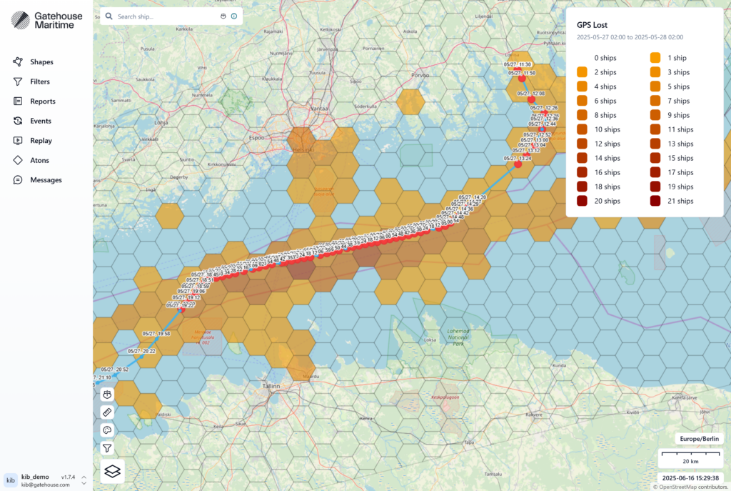
Here’s how it works:
- Continuous Monitoring: GPS Lost actively scans for signs of GPS loss or interference across defined maritime zones.
- Historical Analysis: Operators can track patterns over time, revealing trends in jamming activity.
- Granular Data: Events are visualized using a grid system, color-coded by frequency and affected vessels. Users can drill down to see which ships were impacted and where signals were lost.
- Evolution Over Time: A built-in timeline allows stakeholders to follow how jamming incidents shift and spread.
With this insight, operators and authorities can take more informed and timely action.
Moving Forward
The maritime sector cannot afford to operate in the dark. As GPS interference becomes more widespread and sophisticated, the ability to detect, analyse, and respond must evolve just as rapidly.
Tools like Advanced Analytics with GPS Lost equip stakeholders with critical situational awareness, offering not just snapshots, but ongoing visibility into where, when, and how jamming affects vessel operations.
In a world where positioning data is no longer guaranteed, proactive monitoring isn’t just a nice-to-have, it’s a necessity.
Authored by
Kim Bøjlund
Product Manager, Gatehouse Maritime
Watch GPS Lost in Action
Other knowledge
Let’s get in touch
Do you want do know more about our solutions?
Our experts are ready to answer any questions you might have and show you how our solutions can benefit your operations.